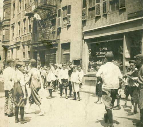
West End History

Today it is one of Boston’s great economic engines and most overlooked residential neighborhoods, but what was the character of the West End when British guns roared from its shores towards Bunker Hill, or as it turned out miles of rope for Boston’s merchantmen? The history of the West End is a history of change, from 1700’s farmland to 1790’s elite enclave: from 1800’s Black American neighborhood to 1900’s immigrant mecca; and from 1960’s tragedy to today’s modern community. Few of the city’s neighborhoods have changed so much, and led Boston through so many challenges. Meet the characters, explore the places, and discover the stories of “the greatest neighborhood this side of Heaven.”

John Smith's Map of New England, 1624
New England : the most remarqueable parts thus named by the high and mighty Prince Charles, prince of great Britaine (Smith, John. "New England." Map. 1624. Norman B. Leventhal Map & Education Center).

In 1625, two years after arriving in Massachusetts, Englishman William Blaxton settles on a plot of land on the Shawmut Peninsula that includes much of what is now Beacon Hill and the West End. Five years after, he allows the Puritan community living in fresh water-deprived Charlestown to settle on his land. Eventually, Blaxton departs in 1635 for Rhode Island after the peninsula becomes too overcrowded for his liking, selling off his remaining land to the Puritans. This last plot becomes the Common, a public space for the new town of Boston, which today retains chiefly the same form and function as then (minus some grazing cows and a powder house).

A map of colonial Boston
A rough and inaccurate sketch of the streets of Boston as they are supposed to have been first laid out & the owners of the soil, from 1630 to 1650 or thereabouts (BPL, Leventhal Collection)

The New Fields (West End) which is cut off from the rest of the city by the Trimountain remains pastoral due to its isolation. Eventually, industrial buildings spring up along the Mill Pond, and a small cluster of mansions are built at Bowdoin Square, where Charles Bulfinch is born on the eve of the Revolution. The city’s textile mill, early rope-making facilities, a windmill and and copperworks are all established around modern-day Thoreau Path and Nashua Street.

The Mill Pond depicted on top right of John Bonner's map of 1722. (Norman B. Leventhal Map & Education Center at the Boston Public Library)

In 1643 the town of Boston permits Henry Symons and five associates to dam up a marshy cove which occupies an area bounded by today’s Causeway, Merrimac, and Washington Streets, thus creating the Mill Pond. The tidal power harnessed by the damming enables the operation of much needed grist, saw, and chocolate mills for the 150 years, but also creates a public nuisance from the dumping of industrial waste and animal carcasses. In 1807, the Town authorizes the filling of the Mill Pond that allows for the building of a canal, rail lines, businesses, and homes.

View of a ropewalk running towards Charles River from an ink and watercolor on paper by William Wood, 1775. (Courtesy of Mass. Historical Soc.)

In 1717, Jonathan Belcher purchases a piece of land along the Charles River where he builds a copper works.  Belcher’s venture joins the other main industries of the “new fields” or “West Boston,” namely distilleries, sugar houses, and rope walks. Rope walks – long, narrow plots with covered walks and sheds housing rope-making operations – dot the landscape of West Boston. They will supply rope mainly for the ship building industry from the mid-17th to the late-19th centuries. In the beginning of the 19th century, a canal is built through the Mill Pond in order to connect the Middlesex Canal with the Mill Creek, enabling the efficient transport of raw materials and manufactured goods to and from Boston Harbor.

Illustration of the Battle of Bunker Hill
View of the attack on Bunker's Hill, c. 1783. The 4 ships pictured are misplaced; they were positioned on the far side of Charlestown. The guns and mortars' firing from Boston are located in the West End. Old West and the Mill Pond are also visible. (Yale University Art Gallery)

While Boston is under siege by the newly formed Continental Army under General George Washington (still little more than a militia), British batteries on Barton’s Point in the West End are set up to defend against colonial aggression from batteries on Lechmere Point in Cambridge. British soldiers dismantle the steeple of the first West Church after it is suspected that the structure is used to signal the rebelling colonists.

Portrait of William Cooper Nell
William Cooper Nell from the collections of the Massachusetts Historical Society

After Boston militiamen insist that Washington admit their Black neighbors into the Continental Army, the city gains a reputation as a welcoming place for free Black people. Local Black Americans congregate on Belknap Street (now Joy) to form the first populous West Boston (renamed from New Fields) community. The community build’s the oldest standing Black church in the United States, founds a school, and develops a successful elite, including William Cooper Nell (above) and Lewis Hayden. They and many others are instrumental in founding the Abolitionist movement, and with White allies like William Lloyd Garrison (founder of the New England Antislavery Society), and Senator Charles Sumner, win support for the movement from a majority of Boston residents on the eve of the Civil War.

Boston and Lowell Railroad Station on Causeway St., erected in 1835. (Digital Commonwealth)

By the second half of the 19th century, all railroads connecting Boston to points north and west of the city cross the Charles River, and four of these eight railroads erect depots in the Bulfinch Triangle sitting atop the old Mill Pond. In 1835, the Boston and Lowell Railroad (B&L) builds a train depot on Causeway Street, and is soon joined on that same street by the stations of the Eastern, and Fitchburg railroads, and the Boston and Maine Railroad (B&M) a few blocks south at Haymarket Square. As the B&M consolidates its operations by acquiring competitors, it chooses to unite all its lines at a new North Union Station (1893) on Causeway Street. In 1928, North Union Station is replaced by the new North Station and Boston Garden built further down the block.

The 54th storming Fort Wagner
Lithograph of the 54th storming Fort Wagner by Kurz & Allison Lithography Co. c. 1880-1899 from the National Portrait Gallery, Smithsonian Institution)

The West Boston Black community leads efforts to recruit the famous 54th Massachusetts Infantry, the first free Black military unit of the Civil War. This is soon followed by the 55th Regiment, and perhaps most importantly, the elite 5th Massachusetts Cavalry. These divisions are among the first to enter Charleston and Richmond in the final months of the war.

Spring Street c 1900
Spring Street c. 1900 looking towards the Bulfinch Building (Boston Public Library)

By the close of the Civil War, the West End reaches the rough boundaries of Pickney, Sudbury, and North Washington Streets (the area represented by The West End Museum.) While Irish immigration had started decades earlier, it does not significantly affect West End demographics until 1860-1880, when the overflow of the North and old South Ends, along with the establishment of a new elite development in Back Bay, opens the West End to immigrant families. Successive groups of immigrants from Italy, Eastern Europe and other nations overlap one another in the West End, building a large multi-ethnic community that survives until the neighborhood’s destruction in 1959.

Portrait of a balding man with a large moustache
Portrait of Martin Lomasney (Boston Mahatma, Ainley)

The Mahatma, Martin Lomasney, rises to power in Ward 8. Lomasney, the longest serving and most prominent ward boss in Boston history, holds mostly unquestioned power in the neighborhood for five decades. Representing the unique culture of the West End, he is the only Irish boss to appoint a non-Irish person to any city office, and makes the West End Boston’s most unified political block into the era of Mayor Curley.

West End boys at Poplar and Brighton Streets (The West End Museum)

Italians and Eastern Europeans, mainly Jews, make up most of the West End’s population of 18,442* in 1920, supplanting the former majority of Irish and Eastern European Jews, who from 1895 onwards had begun their diaspora to Dorchester, Roxbury, and the suburbs. From this time forward, the West End’s population will only decrease, the effect of the Great Depression, World War II, and second generation Americans leaving to seek middle-class living in different neighborhoods of Boston or the suburbs, leading to a decrease in overpopulation and “de-slumming”**. The City of Boston’s announcement in 1951 that much of the West End neighborhood will be demolished as part of an urban renewal plan inspires further migration until only 2,700 families remain in the Spring of 1958.


*U.S. Bureau of the Census, 1920 **Death and Life of Great American Cities, Jane Jacobs
Remnants of the Government Center Project on fire
Remnants of the Government Center Project with burning debris (WEM Archives)

Mayor John Hynes proposes a plan for a New Boston, aimed at luring suburbanites back to the city by offering them modern living space close to downtown. With a prime location between the scenic Charles River and the commercial district, the West End is chosen as the first large-scale site for this age of renewal. Driven by the use of eminent domain and Federal redevelopment funds, the West End Project ultimately leads to the destruction of the neighborhood’s residential core (the Upper End) in 1958 and 59. More than 12,000 West Enders are forced to move out of their homes and community. Supplied with inadequate relocation support, most see their future rents more than double. A promise to bring West Enders back never materializes, and further seizures claim the neighborhood’s eastern (Lower End) section in the 1960s.

The Charles River Apartments with West End Project Sign
The Charles River (now West End) Apartments with West End Project Sign (WEM Archives)

Charles River Park now rises from the rubble of the West End. The neighborhood is eradicated; its former parts are being absorbed by abutting districts. Beacon Hill incorporates the North Slope, the Bulfinch Triangle is assimilated into the North End, and the rest is divided between Charles River Park and Government Center. A new, middle class community forms in the more modern, taller “suburb in the city” amidst the dismantled West End.

Aerial Photo of the West End

Beginning in the mid-1980’s, displaced West Enders begin to reconnect and advocate for their lost community. Over the next two decades, the West Ender newsletter begins publication, the West End Historical Association forms to preserve the memory of the former neighborhood, and the Old West End Housing Corporation fights for and wins space for displaced West Enders in the modern West End. Today, amid the rising glass towers surrounding the Bulfinch Triangle, the historic West End is memorialized in West End Place and West End Park.

West End Place
West End Place and the Tip O'Neill Building in 2019

After the sale of Charles River Park, consultants asked to find a new name for the area to instill a sense of community, come up with an ironic suggestion: the West End Apartments. The name West End returns to common use — reestablishing the neighborhood after a half-century interlude. The West End Museum, dedicated to telling the story of the West End, Boston, and the challenges of urban development opens. Though the demolition of the viaduct and the Green Line tracks is a welcomed improvement, other projects continue to be a concern in the area and community organizations, such as the West End Civic Association, continue to engage with developers and the city in order to protect the interests of current residents.

More Neighborhood Stories

BusinessNew FieldsPolitics & LawYankees & Brahmins Genealogy of Thomas Clarke

Thomas Clarke

Thomas Clarke The Early Settlers of the West End (1630 – 1645): Thomas Clarke, Speaker of the House of Massachusetts Bay Colony Thomas Clarke owned vast amounts of land and businesses across Boston. He was very much involved in the local government throughout his life and commanded the Suffolk Regiment in 1651. Later, he would go…

Read article
Art & LiteratureBusinessImmigrant NeighborhoodReports & AnalysisSocial & Religious Institutions Map of Radio Stations in the West End

Mapping Amateur Radio Stations in the 1920s West End

Mapping Amateur Radio Stations in the 1920s West End Overlaying historic maps of the West End over a map of present-day Boston can contextualize the locations of amateur radio stations in the West End during the 1920s. Leon W. Bishop, an early pioneer of amateur radio broadcasting, moved to 18 Irving Street in the West…

Read article
City PlanningImmigrant NeighborhoodNeighborhood LifeSocial & Religious InstitutionsYankees & Brahmins Lee's three masted schooners sailing

Joseph Lee, Jr. and the Founding of Community Boating

Joseph Lee, Jr. founded the “Community Boat Club” in 1937 so that West End youth could sail out from the Charles River Esplanade. Community Boating, Inc. was officially incorporated in 1946, and remains the oldest continuously operated public boating organization in the United States.

Read article
City PlanningImmigrant NeighborhoodNeighborhood LifeSocial & Religious Institutions The New Years Card sent by Brophy and Lee with illustrations of new buildings and other proposed child-centered sites with

An Appeal for Children’s Recreation and Community-Led Development in the 1930s West End

Ten-thousand West Enders received a creative New Year’s greeting card demanding improvements in children’s recreational opportunities, from William F. Brophy, a lawyer who worked in the West End, and James Lee, Jr., the son of the “Father of the Playground Movement” in America.

Read article
Find by Era
BusinessNew FieldsPolitics & LawYankees & Brahmins Genealogy of Thomas Clarke

Thomas Clarke

Thomas Clarke The Early Settlers of the West End (1630 – 1645): Thomas Clarke, Speaker of the House of Massachusetts Bay Colony Thomas Clarke owned vast amounts of land and businesses across Boston. He was very much involved in the local government throughout his life and commanded the Suffolk Regiment in 1651. Later, he would go…

Read article
Find by Topic
Art & LiteratureBusinessImmigrant NeighborhoodReports & AnalysisSocial & Religious Institutions Map of Radio Stations in the West End

Mapping Amateur Radio Stations in the 1920s West End

Mapping Amateur Radio Stations in the 1920s West End Overlaying historic maps of the West End over a map of present-day Boston can contextualize the locations of amateur radio stations in the West End during the 1920s. Leon W. Bishop, an early pioneer of amateur radio broadcasting, moved to 18 Irving Street in the West…

Read article
City PlanningImmigrant NeighborhoodNeighborhood LifeSocial & Religious InstitutionsYankees & Brahmins Lee's three masted schooners sailing

Joseph Lee, Jr. and the Founding of Community Boating

Joseph Lee, Jr. founded the “Community Boat Club” in 1937 so that West End youth could sail out from the Charles River Esplanade. Community Boating, Inc. was officially incorporated in 1946, and remains the oldest continuously operated public boating organization in the United States.

Read article
City PlanningImmigrant NeighborhoodNeighborhood LifeSocial & Religious Institutions The New Years Card sent by Brophy and Lee with illustrations of new buildings and other proposed child-centered sites with

An Appeal for Children’s Recreation and Community-Led Development in the 1930s West End

Ten-thousand West Enders received a creative New Year’s greeting card demanding improvements in children’s recreational opportunities, from William F. Brophy, a lawyer who worked in the West End, and James Lee, Jr., the son of the “Father of the Playground Movement” in America.

Read article

The West End Museum Archives

The West End Museum Archives are an essential part of the Museum’s mission. They contain the collected material culture of the West End, including objects, documents, videos and more. You can learn more about contributing to, or accessing, The West End Museum Archives by clicking the button below.