Where is the West End?
Executive Director Sebastian Belfanti explains the many answers to a common question: where, geographically, is the West End?
It’s quite common for visitors to the WEM to ask where the geographic boundaries of the neighborhood are. My usual answer is: ” If you’re asking us, from the Charles along Pickney, across the Statehouse, along Ashburton, through the middle of Pemberton Square, up Sudbury and then along Washington Street, but today it ends at Cambridge Street.”
The reality is that the answer to that question is much more complex, it changes with time, and with perspective as well. The area we, as The West End Museum, represent is different from the area represented by the West End Civic Association, the one referred to by the urban renewers, the one defined by political districts, by neighborhoods, and so on.
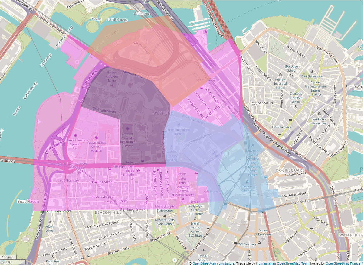
Below I will go through five maps that give a more complete answer to the question: “Where, exactly, is the West End?”
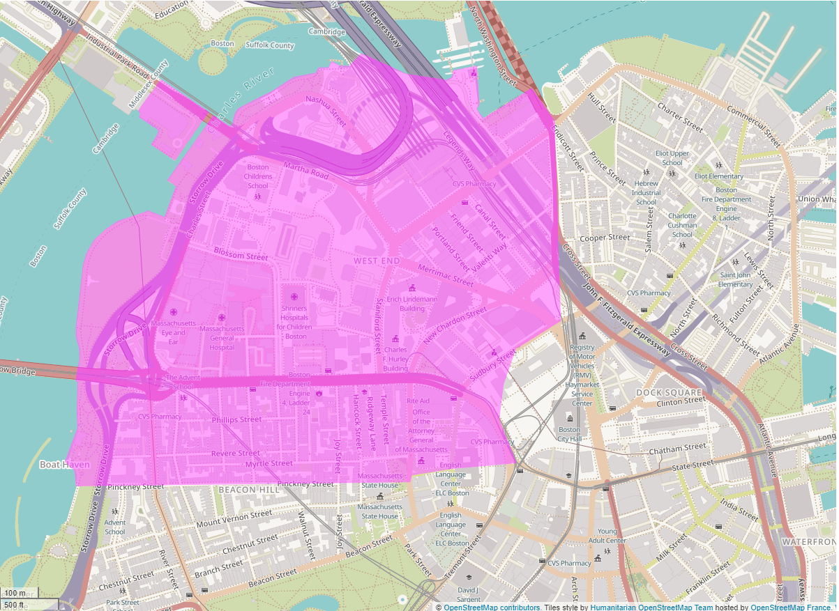
The Historic West End
The Historic West End is a term used by the WEM to define the space we represent. It roughly matches the boundaries of the West End in 1950, but the pre-renewal West End was always more fluid than the map suggests. There was, for example, a fluid boundary between Canal Street and Washington Street where the North and West Ends faded into one another. The eastern boundary faded into Scollay Square, and Pickney Street was not nearly as strong of a divider as Cambridge Street has become between the West End and Beacon Hill. Regardless, these boundaries are the best match to a defined West End that is, more or less, recognizable from 1630 through to the present day.
The Historic West End will be included in all the maps found in this article, to provide a consistent point of reference.
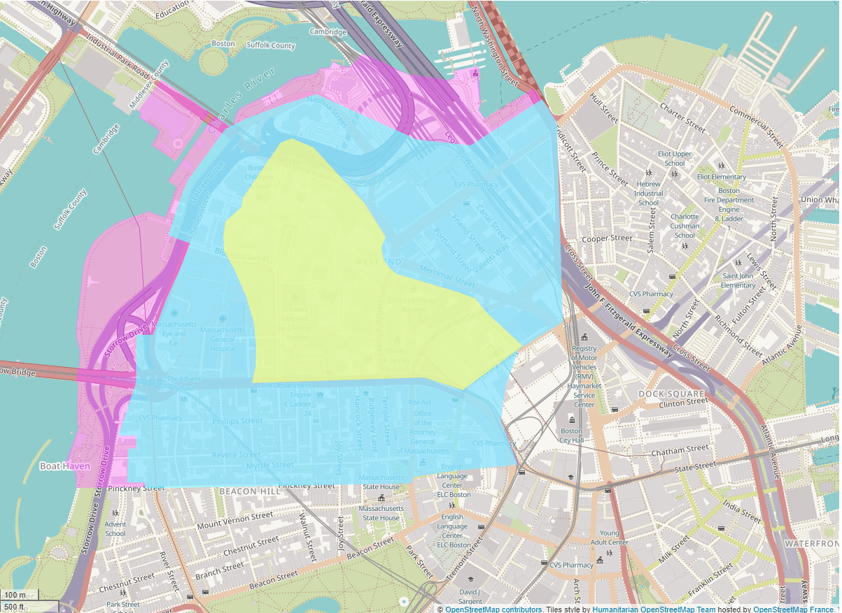
The New Fields and West Boston
Before the West End got it’s name, the area was referred to as the New Fields (colonial) and West Boston (1765 – 1880). Both of these regions look smaller than the Historic West End on a map, but that’s somewhat illusionary. West Boston is smaller only because the remaining area was still part of the Charles River in the mid-19th century. The New Fields didn’t include Beacon Hill, but its diminutive extent is mostly due to the much smaller version of Boston it occupied, before any major landfill project.
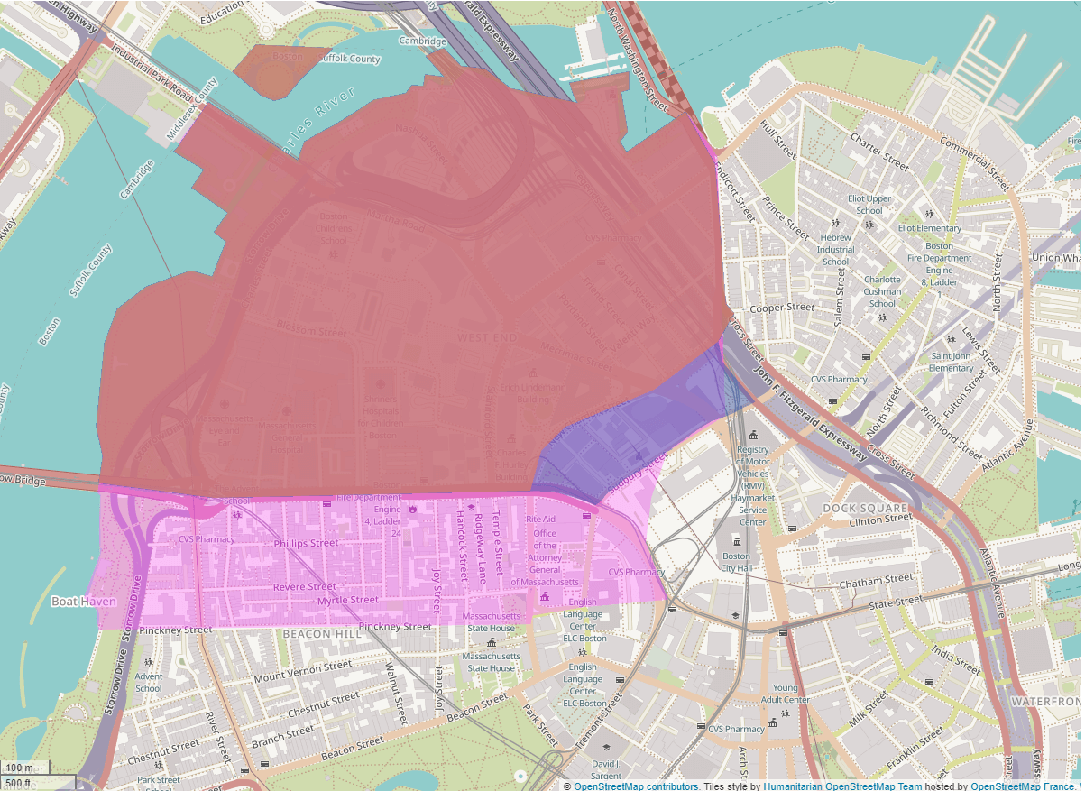
Two Modern West Ends
Since 2009, when the West End was reinstated as a city-defined neighborhood, it had separate political and neighborhood boundaries. In 2024, the city-defined political and neighborhood boundaries, which define its area of influence for purposes of development and governance, become the same area. The West End makes up the northernmost portion of District 8, covering Wards 3.05, 3.09, and 3.10. However, the city boundaries still don’t perfectly match those defined by the West End Civic Association, which extend an extra block to Sudbury Street.
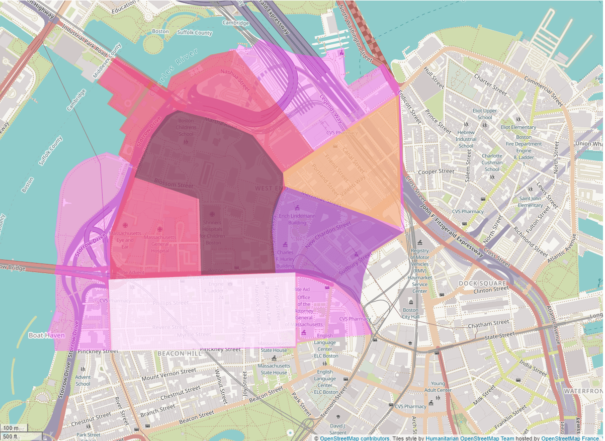
Subsections of the West End
Today the West End includes 2 subsections, Charles River Park and the Bulfinch Triangle. The Bulfinch Triangle has had the same basic boundaries since it was built in the early 19th century, and Charles River Park is a development (smaller than the area shown) as well as a former neighborhood of Boston that was defined after urban renewal (the map boundaries).
The Historic West End includes 4 subsections, the Upper End, Lower End, North Slope and Bulfinch Triangle. The North Slope (of Beacon Hill) was incorporated into the Beacon Hill neighborhood in 1963 and the Bulfinch Triangle is unchanged from the area noted above, except that the Government Center Project cut off one point of the triangle. The Upper and Lower Ends split an area the WEM commonly refers to as the Flat, or the area that is conceptually continuous with the flat land that originally extended from Beacon Hill to the Mill Pond (the New Fields). The two Ends split the Flat across Staniford Street. The Flat is the area that urban renewal officials commonly referred to as the West End in the 1950s, and is still sometimes confused with the West End.
Urban Renewal Project Areas
The history of the West End after 1953 is defined by its intersection with 3 urban renewal projects that tore the neighborhood apart socially and physically between 1950 (when John Hynes came into office as Mayor) and 2006 (the Big Dig).
The West End Project cleared the entirety of the Upper End, which had been composed of the West End’s best housing stock. The Government Center Project, which extended outside of the Historic West End, cleared the Lower End as well as the area from Scollay Square to Dock Square. The North Station Project was not a full clearance project like the other two. Pre-1970 buildings in that project disappeared slowly between 1972 and 2006, so that only 3 remain today, including the iconic “Last Tenement”.
Article by Sebastian Belfanti
Source: City of Boston; Boston Planning and Development Association; The Urban Villagers, Herbert Gans; Boston Public Library; The West End Museum; Open Street Map


